Helios Visions assisted with the facade restoration of The Cook County Hospital in Chicago by capturing images of the building using autonomous drone technology and high-resolution sensors.
Project Description
Walsh Construction is working on the Cook County Hospital renovation 
Conventional methods would have required scaffolding and/or lift, cost upwards of $50,000, sometimes require road closures and can be unsafe.
With drone based inspection we were able to autonomously fly around the entire building using a preplanned flight path(with obstacle avoidance) to capture the images required for visual evaluation in about a day for a fraction of the cost in a much safer environment.
Data Collection
Using a drone with a high-resolution image stabilizing camera, we able to capture close-up images and video of the entire exterior of the building. The high-resolution images were sharp and could be examined with pinch and zoom technology on a mobile phone.
The preplanned flight was launched, engaging the drone to autonomously fly around the entire exterior of the building while capturing high-resolution images of the facade at a close distance. Moving around the building and up floor by floor until complete.
A second preplanned top-down flight plan was conducted to capture the rooftop condition; and a third flight was flown using manual control, ensuring a high sampling distance and sufficient overlap among images for the 3D structure model.
Final Results
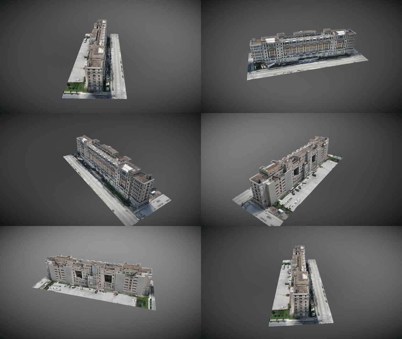
The building facade is documented using high-resolution images that include location information. Those images were also merged together to create a 3D point cloud of the building structure.
The high-resolution images were used by engineers to begin the examination of the current condition of the building facade and rooftop.
The 3D point cloud data was also exported into BIM software for continued analysis and kept on file for historical record.
The images and 4k video footage were delivered almost immediately requiring minimal processing. This helped the engineers to get started planning the renovation of the historical landmark faster than in the past.
The 3D point cloud takes longer to process due to the processing time required to render.
After drone data delivery
Once the drone data was reviewed by the client, high-resolution images, video clips, 3D point cloud and aerial VR tours were shared with other team members including engineers, building management and ownership.
Now knowing the full extent of the buildings exterior condition, restoration costs can be more accurately estimated, resulting in a faster assessment at a reduced cost.
Advantages of Drone-based Building Facade Inspections
In Chicago alone, there are hundreds of historic buildings which need to be documented and preserved. Such buildings have an exceptionally high value from a historical preservation perspective.
Using autonomous drones to take high-resolution images and video for building facade inspection is the future of ongoing facade inspection. In Chicago for example, the owner of any building over 80 feet tall is required by a facade ordinance to provide an up-close observation of the materials on the building to comply with the City of Chicago’s “Exterior Wall Program”.
Using drones for ongoing building facade inspections is a more efficient and economical way to monitor building conditions over time and enable better renovation and restoration planning.
And when working on a large project with a lot of public interest, sharing the drone data would be a big benefit, since the data can be easily shared with anyone involved in the project.


